Three Sub-catchments in the Upper Aire
The Yorkshire Dales National Park Authority asked Viridian to analyse certain sub-catchments of the Upper Aire to enhance the landscape’s ability to mitigate flooding and understand natural flood management (NFM) options. Viridian created a variety of maps to illustrate the results, as well as derived data layer to feed directly into the Authority’s geographic information system (GIS).
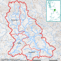
The Upper Aire catchment covers approximately 370 km2 within Yorkshire Dales National Park. The specific areas that Viridian was asked to look at are on the West side of the catchment, labelled here as Gargrave, Earby, and Glusburn (which cover 84, 56, and 41 km2, respectively). These sub-catchments primarily consist of pasture and natural grassland, whilst higher elevation areas transition to heath, moorland and peatland.
As these sub-catchments coincide with the catchment edge, it was straightforward to process them through the Viridian system since the upstream sources are contained within each sub-catchment. The flow paths were calculated for these landscapes and evaluated for their current ability to mitigate flooding. Those areas found to be performing poorly were evaluated against different habitat types to find out what land use would maximise the ability of the landscape to slow the flow of water into the river system, and thus reduce the risk of the river bursting its banks further downstream.
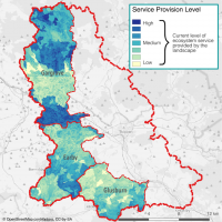
This map shows the current flood mitigation ability of the landscapes within the Gargrave, Earby, and Glusburn sub-catchments. The hydraulic treatment of the landscape is convolved with factors such as vegetative cover, peak monthly rainfall, soil, etc, to establish how water flows across the landscape. Where Viridian scores the landscape poorly indicates where habitat planting will have a greater impact in mitigating flow, and hence flooding.
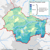
This map shows the current flood mitigation ability within the Glusburn sub-catchment. The calculations are performed on a 5m pixel scale allowing high resolution of flow and landscape features to be recognisable in the output maps. Here we see the southern river branches are relatively well provisioned; this is mostly due to peatland and moorland in the southern reaches of this sub-catchment.
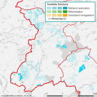
This map shows the most effective 20% of solutions to improve local flooding problems within the Earby area of interest. The solutions entail mainly creating wetlands: either rewetting peat, creating leaky dams, or forming ponds/swales, depending on local circumstances. Wetland is often selected for flood mitigation as it is effective at slowing flows across the landscape, reducing flow volumes downstream whilst offering a lower risk of synchronising peak flood heights than would planting trees.

